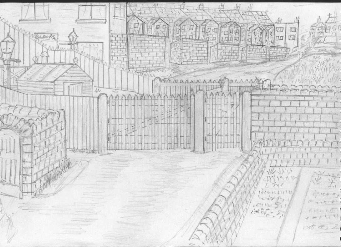
This sketch may bring back a few memories to many of the older folks in Mansfield. The picture shows many interesting points of our history in such a small area, all of which has since disappeared.
Firstly the picture shows the top of the back lane to Bradder Street. On the left we have the doorway to the front of the Engine Sheds. The Level Crossing leading to the Brickyard, of which Cinderella’s walk is shown crossing the front of the gates.
The wall of the Engine Sheds continues along Cinderella’s Walk, separating the sheds from the walk and the small wall to the front right, is the wall to the gardens of Railway Sidings. The wall the other side of the garden wall, is the wall that crosses the top of Bradder St. and protects the railway lines, where Cinderella’s Walk continues towards town.
The two sets of gates open outwards for obvious reasons, and were operated and guarded by a man who’s name was Joe Oliver, he was a great friend of my Father, and his hut can be seen to the left of the gates.
The large gates were for the vehicles and carriages, and the small gates were for pedestrians. You had to be grown up before you were allowed to use the level crossing by yourself, occasionally Mr Oliver would allow me to cross, but he was there to watch me.
Where the fence rises, and the two gas lamps are situate, were the steps to the footbridge over the lines. The white house on the left was Bloors Off-License. If you walked past the front of the shop, it lead you to the Hayfield.
The Terraced houses were Victoria Terrace, and at the far end of the houses was the Brickyard Club, which to the rear of it was what used to be the Brickyard Pond. All the overgrown area on the right was where the actual Brickyard used to be, which did include the old Ten Row houses which faced the railway.
All this area was unmade roads, which lead you to Moor Lane. On top of the embankment was St. Aiden’s Church, and then Moor Lane School , and finally Sutton Road. Walking along this route you passed on the right, Cambridge Street, Princess Street, New Victoria Street, and Moor Street.
Opposite Moor Lane School was waste land that had been covered with ash. It was waste land for many years until Maun Industries built a factory on there, now I understand there are houses now built there.
A small area. A small road. But an awful lot of history. I am so pleased that I and my family were part of it.


No Comments
Add a comment about this page