The name Quarry Lane appears from time to time on the site and it does have a lot of history, so I would like you to accompany me on a trip down memory lane.
Quarry Lane
Quarry lane did lead to two sand quarries, and a stone quarry. The whole length of the lane stretches from Portland Street to Sheepbridge Lane. Probably the odd thing about it was, the lane only had one causeway, (kerb, pavement or walkway) call it what you may, and that was along the right of the lane from Portland Street, and right up to Sheepbridge Lane. All the ground to the right of Quarry Lane was much higher than on the left, that is because of the valley of the river Maun where the river meanders it’s way through the lowlands of Mansfield. Everything built on the lane up to Sibthorpe Street was made of stone, not surprising really with the number of stone quarries in the area. Since the late 1930’s, I have walked, cycled, played, and driven along Quarry Lane.
Imperial Laundry
The lane starts from Saint Marks Church and the Henley Hall with a stone wall either side of the road. Quarry Lane was a little more than a slight incline up to the entrance to Mansfield Town Football Club. On the corner, over the wall on the left hand side, was the Imperial Laundry. and next to that, also over the wall, the Field Mill Dam, which also housed the largest Water-Wheel in the country at that time. I believe this was dismantled around the early part of the 20th century, after the closure of the Field Mill factory. This factory was eventually taken over, and became the home of a company named Coobrey’s. It was in the Wood and Upholstery business and went under the trade name of Field Mill Upholstery. One could always hear the wood cutting machines during working hours. On the right hand side at the beginning of Quarry Lane was a stone building of a religious ownership, this may have faced Portland Street. A very large house, with a very large entrance was the first house at the bottom right, this was later to become a Social Club for the football supporters.
I cannot write of this area without mentioning the old stone horse trough that stood on Nottingham Road at the entrance to the Imperial Laundry. (I wonder what happened to it)??
The Football Ground
Next, there was a large gate which lead to the only seating area at the Mansfield Town football ground for the better off folk who could afford to sit down and watch the game! The seats were not the bucket type seats of today, but stepped, wooden bench seats in long rows on concrete steps. Next to this was the building where the players and directors, and any opposing teams went through the front doors. At the side of this building was the wide area which lead to the main gates with turn-styles to the main standing areas. Football in those days did not have the kind of money that is splashed around today. Although their wages were a lot higher than that of a working man, even in those days..They were not in full time employment, but if they played and won, they received £23, If they drew, £21, and if they lost they received £20 Across from the football ground, the high stone wall continued.
‘Bike park’
On the same side as the football ground, and a little further along Quarry Lane, there was a block of stone terraced houses, about six cottage type houses in total. They were two stories of two up two down. There was a passageway in the middle of the block that took you to the rear of the houses where the small gardens ,and a bank of outside toilets stood. The back door went into a small but cosy kitchen/living room. An old rocking chair by the fire, and a small but very handy dining table would compliment the room! On match days, the people who went on their bikes to the match, would leave them at the rear of the stone houses, and for the cost of an old 1d[one penny]. The bikes would be safe when they returned. A lady and her two daughters whose surname name was Thompson, lived in one of the stone cottages. Come to think of it, there were many of this kind of stone housing blocks throughout Mansfield.
Quarry Lane divides into two lanes
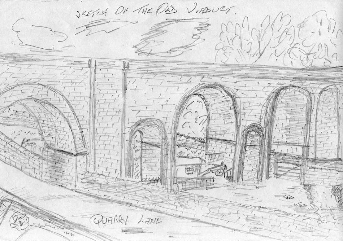
About 100yds further along, Quarry Lane narrowed, and divided into two separate lanes. The road to the left was an unmade road. The high stone wall had become much lower and had round iron rails, three bars high built on top of the much lower wall. Over the rails was a drop of about 12 feet, and then an embankment down to the river Maun. The unmade road continued under one of the arches of the spur viaduct that came from the main line from close to the old Co-op Dairy and the Mansfield Railway Station. The viaduct was of a beautiful design of bridges, all built of stone. Continuing along the unmade road under the viaduct, and on the right was a gate which lead you to the river Maun, which at this point went underneath the road and weaved it’s way down to Field Mill Dam.
‘Shoggy’ Green
The gate was also security for the huts and styles that were under two or more of the arches. They were owned by ” Shoggy ” Green, who lived near the bottom of Bradder St. It was here where he kept his horse and dray, and also his pigs and hens. They were very much sheltered in the Hollow.
Viaduct
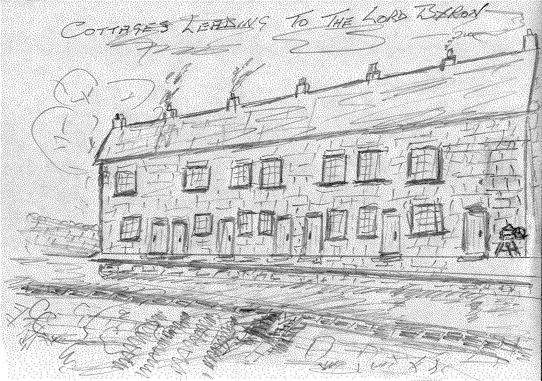
Continuing along this road would take you past ” Fatty Man’s Bank It was at this point that once again you passed under another viaduct.This viaduct line was another offshoot line from the main Mansfield, Nottingham line , via Sutton Junction. The spur line was from the rear of the Engine Sheds, and this spur line was crossed by a pedestrian crossing of Cinderella’s Walk. The two viaducts met and joined further down the lines nearer to Nottingham road. After passing under the bridge of this second viaduct, the road then again forked. The left fork leading to Matlock Avenue, the right fork leading down past another block of seven stone cottages on the right, that had the backs of the houses at the side of the river Maun. They had raised front gardens at the front ,across the unmade road. The road eventually ended in the Lord Byron Yard, where the old Pub stood in the left hand corner, attached to another three terraced houses, this time 3 story stone Houses , which were built onto the high rocks. At the top of the rocks was Matlock Avenue and Cromford Avenue, known locally as “The Top Field “.
Railway Line and Quarries
We now return to the first viaduct again and take the left turn, and pass some allotments on the left, and Fatty Man’s Bank on the right, before you proceeded under a long single stone built underpass that carried the trains to and from the Central Station on the L.N.E.R. ne connecting to the L.M.S. line. This underpass took you to the old Sand Quarry on the left, an area often used by the courting couples of yesteryear. If you didn’t turn left, but went straight on, the stony path continued into Gregory’s Stone Quarry. This Quarry was a working quarry throughout my childhood, we often heard the explosions when ” Blasting ” was taking place. I think it was a working quarry right up to the 1960’s and maybe the 1970’s. High Walls & Allotments
We now return to where Quarry Lane continues on the right fork. The stone wall on the left continues at a height of about 4ft-6ins right along until it reaches the first arch of the viaduct. It then continues at the same height along to the bottom of Sibthorpe St. The archway over Quarry Lane was quite a low bridge, which eliminated a lot of traffic from getting to Sibthorpe Street, and Bradder Street. Although, the wall was only 4ft 6ins high on the Quarry Lane side, over the wall there was quite a big drop down to the river valley. We now return to the other side of the road again, back to the fork in the road. The higher stone wall from the cottages we passed continues even higher, but at this point, another wall has been built. This wall is only 3ft in height, it has been built as a retaining wall for the now even higher first wall to allow for the higher ground of the contours . Between the two walls, soil has been banked and grassed to form a support for the high wall. Over this wall, there are many, many allotments.
Stone Steps
Both walls continue along to the first arch of the viaduct. It is here we find a most interesting part of the stonework. At the base of the arch, are some very old worn stone steps. These steps lead up to an old stone stile of approximately 20ins in height, which over this, is a cinder path that takes you through the allotments, past the rear entrance to Field Mill Football Ground, and continues it’s uneven way past the backs of the houses of Lord Street, to come out on Portland Street, close to what was The Old Black Bull Public house. So back to the old stone steps that were so worn out in the middle, one had to watch where they placed their own steps when walking up or down. The actual steps had a 4ft wall either side which all formed part of the supporting strength for the higher wall protecting the allotments. Between the actual bridge and the steps was another banking for the corner of the viaduct, again ensuring a non-slip bridge base. On the other side of the bridge was another grassy bank, giving the same support to the wall and railway bridge.
Next we have a very high stone wall which forms a support for the gardens of a terraced row of stone cottages. There are two lots of steps which lead down to Quarry Lane. The cottages are still there, so they require no further description, only that the view from the front gardens were superb. Bruce Aram, an old school friend and playmate of mine used to live at, I think it was number eleven. I remember that Sibthorpe Street was access to quite a large Sand Quarry, that had been excavated from the land between Bradder Street and Sibthorpe Street. The quarry went right to the edge of Sibthorpe St., hence there were no houses built on the left hand side of Sibthorpe St.
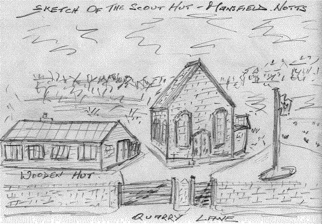
Across the bottom of Sibthorpe Street there was a pair of semi-detached stone cottages, and at the rear of the two cottages was an old type slaughter house which was attached to the rear of the pair of semi cottages, alas, all gone. After the pair of semis’ the wall continued all the way to the bottom of Bradder Street, and the only access through the wall was a five barred gate and a pedestrian gate which lead to the Scout Hut, which was later used by the Sea Cadets, there was also a large wooden hut with a garden at the front.This could have been the Cabbage Club.
Across the road of Quarry Lane opposite the bottom of Sibthorpe Street, the stone wall on that side was now much higher, it had a doorway that had been blocked off, and over the other side of the wall were some steps and the remains of what used to be an old stone house. My Aunt Flo used to tell me that her family used to live there, around the early 1900’s. This must have been a sort of Small-Holding, as from where the house used to be, to the bottom of Bradder St, the cultivated garden grew everything imaginable , it also had mature, Apple, Plum and Pear trees , and never a shortage of water with the river Maun running along side. Also from the demolished stone house to the bottom of Bradder St., the wall to the left of Quarry Lane had reduced in height again to about 4ft, this also terminated at the bottom of Bradder St. The 4 ft stone wall that terminated at the bottom of Bradder St, had now become a 6ft angle-ironed railings, with an iron gate at the end for access to the river and the viaduct base. The 6ft railings continued up to the pillar of the first bridge of the original viaduct that carried freight from the L.M.S. line over the viaduct to the Eastern part of the country from Nottingham and areas. This first bridge, unlike the other bridge on Quarry Lane, has cast iron bridge support members over the road. This viaduct still stands today, it is a tribute to the workmanship of the skilled men who built it in the 1800’s.
After Bradder St, we had the Back Lane, which would take you up to the Engine Sheds, the Railway Crossing, the Brickyard Works, Moor Lane School, Sutton Road, and eventually over Botany to Pleasley. What an adventure that was, it was a sort of Alladin’s Cave of nature and excitement at what you might come across. It was also the short cut we used to take when the Fairs were set up on Chesterfield Road Recreation Ground.
Allotments
The Back Lane was the rear entrances to one side of Bradder St. There was a complete row with openings to the Lane, of outside toilets and separate housing for the ash filled dustbins, remember everyone had coal fires in the days gone by. Each house had a small garden, and the back doors faced each other, this was called “Back to Back” housing, and the two houses shared what was called the Back Yard, on the other side of the Back Lane. The Engine Sheds were completely stone walled in, that is apart from where the railway lines lead into the sheds…Along Quarry Lane from the Back Lane, Quarry Lane on the right, was nothing but allotments that stretched right along to Sheepbridge Lane, then back as far as Cinderella’s Walk. There seemed to be miles of them. There were even allotments between the sheds, the railway lines, the Back Lane and Quarry Lane. Every bit of spare land was allocated to the allotment schemes. There were two five barred gate entrances to the two allotments, one either side the railway lines that proceeded to the viaduct, and from the viaduct, a hawthorn hedge separated the allotments from Quarry Lane, all the way up to the junction with Sheepbridge Lane.
Lord Byron Yard
Another part of Quarry Lane that was of great interest to us at the time was, the small fence with a small hedge that allowed us access to the river and the base of the viaduct’s supports. I still have the scar on my right hand that I achieved whilst climbing one of them, and the river Maun held many interests for us. We now come to the footpath that takes you over the footbridge that spans the river, and on into what was The Lord Byron Yard.***6*** The Pub and cottages have long since gone, but I do remember times I looked in to see if I could see my brother-in-law and my sister Alice drinking a noggin of ale. Of course, when going to High Oakham School from Bradder St., I would take this route through the Byron Yard and over the Top Field. Most days a man would be stood on the bridge leaning over the rail and looking into the river. His name was William Boyd and he lived in the first cottage, closest to the river. He was a Soldier of the first world war, and survived through a gas attack, although it left him with a severe breathing problem. He stood on that bridge many hours, just trying to get his breath.
Kids games
Further along, we come to the wooded area we used to call The Robin Hood, here, we swam, we fished, we swung over the river by bull rope, we made bows and arrows, we made dens, we cooked on fires, all in all we had many happy hours just being kids.
At the junction with Sheepbridge Lane, we had the Crawler, a corner of the river which was quiet, and the river bends after it comes from under the main road, we would also shelter under the road if it rained. As I grew older and had my own children, I also remembered my own childhood, I took my two daughters when old enough to the Crawler, and showed them how to catch fish with a bent pin.
I hope you have enjoyed accompanying me on my nostalgic trip down memory lane…I honestly believe that much of our history should be preserved, because,at heart, we all Love Our Mansfield.
Alan Curtis.


Comments about this page
I can’t believe I have come across this page.
My mother was born in 1 Bradder St, one of eight children, their family name was Humphreys. Her father was William, I never knew her mother’s name, her name was Dorothy, I used to go there for holidays every summer. My Auntie Sarah and her brother, my Uncle Israel, still lived there, a little 2 up 2 down with the toilet at the bottom of the garden just has described by Alan.
I was born in 1946, and remember playing in the river in Quarry Lane, also watching the sheep going along the lane. Were they going to the slaughter house? This must have been in the early 50s, also going across the railway at the top of Bradder St, past the disused coal mine which I thought it was, I also believed my Grandad had worked there.
I would love to know if anyone remembers my family. Also is my memory right about the mine?
My grandfather James Bower used to take me to visit a friend of his who lived by the dam on Field Mill when I was just a small child, I believe this man may have been Shoggy Green. The man we often visited lived over a small bridge off the river Maun on Quarry Lane, in the direction of Gregories Quarry.
My grandfather also had a horse and dray, and lived on Victoria Street for most of his later life until he was 61, when he moved house. I believe firstly collecting scrap metal in the town and later selling fruit and veg to local householders.
He had strong ties with the area around Quarry Lane prior to being in the war with Sherwood Foresters and after. My grandfather was well known in the area and people always knew where to find him – where he kept his horses, on the first field near to Bleakhills ponds, facing the junction with Garth Rd, on High Oakham Hill.
My husband’s grandad, John Edward Sanders was born in 1900 at 22, Freestone Place. His parents were Phoebe and William Charles Sanders. Both John and his father William were miners.
I was very interested in Kelvin Rea’s comments regarding George Moore who was also my GG grandfather..his daughter Minnie Valentine was my g grandmother.I stumbled across this page researching my family tree and was delighted to have a sense where and how they lived.I would love to be put in contact with him..thank you.
Just gone through reading this post again. The last post, sorry, that took me back to my Army Service. Of Faith Taylor, reminded me of a time in the 1940’s, when food was very scarce. There was at the time, an old couple named Taylor, who lived on Bradder Street, they used to sell vegetables from their front room. No furniture, just bags of different vegetables and a set of old type scales. Many is the time I was sent over with two pence to buy some potatoes. Just wondered with being in close proximity , if it was the same Taylors who used to run the Lord Byron. I believe it was Mother and Son who lived there, we used to call the lady, old Lady Taylor and her son… They were lovely people , and very Religious , had what one would call Religious Pictures everywhere. I also remember over the mantle piece, a large sign ” Bless This House” “.84qro
ree LORD BYRON INN, QUARRY LANE ,MANSFIELD. I AM THE GREAT GRAND DAUGHTER OF JAMES AND MARY MARIA TAYLOR. THEIR DAUGHTER GERTRUDE ANNIE TAYLOR WAS MY GRAND MOTHER WHO WAS BORN AT THE LORD BYRONN INN 1895. THE TAYLOR FAMILY WERE LICENCEES FOR MANY YEARS. P.S. THE NAME GONE ROUND AGAIN WITH ME.
Goodness me Tom, I should have known that. My brother Barry used to drive for him…. I have seen his trucks parked on what was the spare land at the corner of Arthur-street and Newgate Lane. My brother Barry also used to bus the Mansfield Rugby Team to their away matches when they were in the league. I do know there used to be a Pegg’s Chemist…
Alan! The JW Pegg was the Parcels Carrier on Pelham St opposite the Telephone Exchange and next to the RSPCA Clinic.
Hello Tom, Nice to hear from you. It is interesting you mention wiring of the building…. And it fits in with Bradder Street’s change over from gas lighting in the houses to having electricity installed . For it was 1953 that the causeway was dug up all along Quarry Lane to lay the cables for electricity to reach the area. Would it have been Peggs the Chemist’s you mention ?
I joined the Sea Cadets in 1948 and we met in the Old Meeting House on Stockwell Gate. I left School in 1952 and one of my first jobs as an apprentice Electrician was wiring some communications equipment at the HMS TS Prince Charles, the job paid for by Mr J W Pegg who had been in the Fleet Air Arm in WW2. I wasn’t aware it was a Church before. Incidentally Mr Pegg had a large motor launch called Pegasus.
The pair of attached stone houses at the bottom of Sibthorpe Street. Were numbered 18 and 19 Quarry Lane. Making the old red brick church , school, that was the Sea Cadets ” Ship “, number 20. The wooden building next to the church was number 21. Number 22 was the house built between Arlington House. And the Back Lane to Bradder Street. The house numbers continued into the Byron Yard. Where the three cottages attached to the Lord Byron Inn were 23,24, and 25.
There were a Mr. and Mrs. Wright who lived at number 81 Bradder St. They had a daughter Mavis, a real tomboy. Used to walk to High Oakham School with her. Mavis’s mum and dad took over the Brickyard Club.
I have just read the comment re Mr & Mrs Wright from Peter Bowler - they lived next door to us until they died and were close to my parents
My brother Stephen and I were born at no 7 Quarry Lane and we knew everyone on Quarry Lane, Sibthorpe Street and Bradder Street
I bet we can’t remember all their names now!
Anyone who remembers us – get in touch
Something about the Scout hut has come to light ! For the last people who used the building during my time in the area , were the Sea Scouts. No one would blame you if you thought the building looked very much like a church. Indeed you would be correct in your beliefs. It was built as a church, a church for the poorer people of the area for alas, the whole area was an area steamed in poverty. It was declared the building would be built of Red Bricks and Large Windows that that looked like a church. The building also had a large wooden floor, which added to the cheapness of the building. Someone asked where this church that was built of Red Bricks was built on Quarry Lane. Apart from Bradder Street, and the detached house next to Arlington House, there was no other brick built houses on Quarry Lane, the whole lane was built with stone. At a later date, the Field Mill changing rooms were built with blocks. As I have said previously , the sketch of the building does resemble a poor man’s church. The red brick church was built for whatever reason, and known as Saint Lawrence’s Church. Well before the Saint Lawrence’s Church we know today. The whole area housed the poorer folk of the town, hence Saint Aiden’s (Iron Church), and the brick built Saint Lawrence’s Church.
Hello Kath Mason, well bless my soul… I remember you and your Mum and Dad very well…Lived up the same Gennel as the Wilsons, Abrams, Locks, Howiesons, Shoggy Green and Powells… How are you Doin’…? To be honest, I have mentioned Joe Smith a few times on this site.. I have also put a page on about The House In The Quarry.. This was where Joe lived. It was the other side of the railway lines from Fatty Man’s Bank. I recall your Mum and Dad being regulars at the Lord Byron with my elder sister , and her husband Reg. Along with the Austins from the big house at the bottom of the street. I do hope life has been kind to you and yours. I often reflect on what a wonderful , but poor , childhood we all had, and very much appreciate those of us who are still here.Best wishes.
Hi Alan, Reading about Gregs Quarry no one has mentioned old Joe Smith who lived in the cottage at the bottom of the quarry.He used to be the caretaker and did try to keep kids out.He did let you go blackberry picking though.The cottage did not have running water and he used to fill a bucket and got his water from a spring that ran into a small pond. He did have it fenced off and you went down three steps to get to it. I know all this because I used to go with my mum and dad and take him his dinner every Sunday which grandma used to make for him Or he would go up to have it with the family at grandma Masons. Dad also kept pigs at the back of shoggy greens under the archers. I had the job of using an old pushchair to hold a bucket of swill mam had boiled on the stove to feed them with.It was not my favourite job let me tell you. Mam and Dad by the way were Cyril and Hilda Mason.
Hello Alan, my dad is John, his brothers were Harry and Harold and they had a billiard table in the front room of18 Quarry Lane where they played against other boys from the area. John says he always won and spent his winnings on condensed milk from the bottom shop. Does anyone remember this?
I have added a page with photos on of 18 /19 Quarry Lane and of my great, great, great grandad, Thomas Mann aka Fatty Mann
Hello Marlene, Lovely to hear from you. If your father was born at 18 or 19 Quarry Lane, then I believe I knew him well.. Was it Bill ? He is the first to recall Shoggy Green. The two houses were on the corner of the Tippin, a pair of stone built semi’s. At the rear of number 18 was the Slaughter House. I do believe your father went to school with my brother Barry. Shoggy Green eh, ” Begone Bego ” Shoggy Green. If your father can cast his mind back to any further memories, it would be nice. Best wishes. Alan
I was very interested to read your article about Quarry Lane as my father, now 93, was born in 18/19 Quarry Lane and live all his young life there. I remember it all very well and have a photograph of my grandmothers house at the bottom of Sibthorpe Street until it was demolished in 1971 to widen the road! My father Remembers holding the horse for Shoggy green. I will attach a photo as soon as I find how to!
Hi Mansfield District Council can help with this. I have emailed the details to you.
The Friends of St. Peter’s Great Berkhamsted are doing some research into graves in the Rectory Lane (Three Close Lane) cemetery in Berkhamsted, Herts., and we came across this entry:-
“….. the Seat of Remembrance was for her husband Richard Mildmay Foot who died 18th Oct 1933, to be built of red Mansfield stone and teak.”
We wondered if ‘red Mansfield stone’ is still quarried and available commercially, in order to undertake restoration of the seat, which has fallen into disrepair. Any help you can give will be appreciated.
Hello Kelly, I’ll do my best for you, although mention of the hut has appeared in the past. I’m not sure of the date it was built, but if I were to guess, it would be sometime in the 1920’s. Very possibly at the time of the 1926 strike, a time when people had more time than they had money or work. Not sure how it was funded, but it was built by the local townsfolk for the local townsfolk. The hut was fitted out, and kitted out with all kinds of modern comforts “of the time ” that is- it was because the locals had too much time on their hands, and was one way of keeping them off of the streets. Inside there was, easy chairs, tables, a wood/coal burning stove to heat the place, settees around the inside walls, cooking stove, sink, cutlery, cups and saucers, sports gear, for football and cricket. And I must not forget the gardening tools, for those out of work who were encouraged to work on the allotment that ran the full length of the front of the hut. There was also another allotment at the rear of the hut. Food such as dinners and teas were also supplied. During it’s heyday, it was used for the few functions that were held in those days, such as funerals, I’m sure there were no parties that were held in those times. The only one I can think of that may have been, was the photograph of the Bradder Street ladies that was taken in close proximity on the Tippin. It must have been in 1941 -42 that during a very heavy fall of snow in the winter, the wooden roof and wooden walls caved in under the weight. I remember most of it very well, for it was our play area whilst growing up.
Does anyone have more information about the wooden hut at the front of Sea Cadets please, also what the scouts hut used to be?
Alan, thank you for sharing your memories of Quarry Lane (including Underneath the Arches). I took up your offer to accompany you on your trip down memory lane and enjoyed every minute of it. Your sketches are most enjoyable. A very good aid for following your trip is the map “Quarry Lane Mansfield, Notts. c1875,” it can be found on the website of the Reed Mill Angling Club. The map shows where the lane divides at various places on the Lord Byron Inn side of the river.
For me, you have brought to life what I had previously imagined was just an unimportant little laneway in Mansfield. My ancestors lived in Quarry Lane from at least 1860 and possibly earlier. My GG Grandfather William Barker was the publican at the Lord Byron Inn and the family were living there in 1860. William was still the publican there until at least 1878. During these years the family of George Moore was also living in Quarry Lane and William Barker’s son Frederick married George Moore’s daughter Marianne. Frederick and Marianne (my Great Grandparents) immigrated to Australia in 1885. Many events, it appears, took place in and around the old Inn, including many inquests. The Derbyshire Times in October 1870 has a report about the fourth annual show of the Lord Byron Celery Society which took place at the house of Mr William Barker, the Lord Byron Inn, Bleakhills. The Slaughter House probably explains why the occupation of my great grandmother’s brother, Mark Moore, was stated as “butcher” in 1871. Mark Moore and his family were living at 3 Quarry Lane in 1911, which I think would have been one of the cottages in front of the “Bike Park”. The Publican that followed William Barker as landlord of the Lord Byron Inn was probably William Lees who is described in December 1882 as “formerly landlord of the Lord Byron Inn”. Alan, once again I would like to express my thanks to you and also to the people who added comments to your pages.
Hello Kelvin, Thank you for your most kind comments…Your Great Grandmother’s brother, would have indeed been a butcher, for the house he lived in, (Number 3 Quarry Lane ) was the one attached to the Slaughter House at the bottom of Sibthorpe Street…In the early 1900’s ,my Aunt Florence, and Uncle Lawson (He was a Gamekeeper for the Duke of Portland,) lived on the Opposite side of Quarry Lane to them. Their stone house was demolished years ago. Regards.
Hello Peter, You and other readers are very welcome to the memories. I believe it is the reason we add our experiences to the site in order that perhaps in years to come, the people of Mansfield will have some idea of how we lived and what it was like to live in the twentieth century. I used to say what a life my parents had, living at a time when there were so many changes to our world. Unfortunately there had to be so many wars throughout the world to achieve the standard of living we enjoy today.. Your Aunt and Uncle’s house would have looked out onto Fatty Man’s Bank. Alan Curtis
Alan, an aunt and uncle of mine, Bert and Doris Wright, (Doris was my dad’s sister) lived in one of the stone cottages you mentioned with the raised front gardens that are still there on Quarry Lane but I don’t remember the number. I think it was near the middle of the row. I went to see them quite a number of times with my dad in the early 1950s and besides the cosy kitchen the thing that seemed unusual to me was the stairs, not wooden ones but stone. They must be quite old, a bit of old Mansfield. Is there a preservation order on them? There should be. I recall we once went to a pub with Uncle Bert I don’t think I was school age so it must have been pre 1952 and can vaguely remember the pub as being at the side of the river. We sat outside. We wouldn’t have walked far - I’ve an idea it was the old Lord Byron. Was it still open in the early 50s? As for Fattymans Bank the last person I heard talking about it was my dad and he died in 1977, I’d forgotten about the place…………….Thanks for the memories.
Hello Berisford, Thank you for the additional information, you’ll be playing in the team on Saturday…. I can see your point about the steps…My guess is, they would have been placed there as a safety measure for the people using Sheepbridge Lane going toward Brick Kiln Lane, from Cinderella’s Walk…(Didn’t there used to be a small Hospital on Brick Kiln Lane ?) Otherwise would it not be that they would have had to cross the Lines twice ? The safety factor being they could walk under the then new bridge.. We in my day used to call them the 39 steps.. and often found them to be very useful…The new pedestrian bridge on Cinderella’s Walk was much easier to take workers at the Hermitage Mill, situate on Hermitage Lane, to their place of work.. People working at Little Matlock Mill would cross the bridge , go through the gates at the end, and walk down left to their place of work… It is only my opinion, nevertheless I do enjoy your interesting comments, knowing the area as you do..Alan
Alan, I understand the cutting was made by the Midland Railway Company around 1870. Prior to the cutting the original 1817 Mansfield Pinxton line crossed the road (level, before the cutting) in the same position as the present day footbridge. The digging out of the cutting enabled the MRC to avoid a level crossing (expense, crossing keeper and keepers house etc.) but more importantly it made great quantity of stone available to be used on the 3 viaducts they (the Midland Railway) were busy building in the town at the time. One thing that always bothered me and doesn’t seem to make too much good financial sense is the construction of that stone staircase/steps. Whilst well within the capabilities of the stonemasons at the time it couldn’t have been an easy task to carve them out of the rock and for what? Access to Matlock Mill and surround (north & south) could have easily been made via the original roadway, a few yards further on, just over the footbridge? There is a rather good photo in the library / museum collection showing the area during the new railway construction. Search NCCW001347 on Google and it’ll come up albeit low resolution. The picture is incorrectly identified as Mansfield Southwell Railway 1871, though you can see it going off in the distance via the Drury Dam viaduct. It actually shows a view of Sheepbridge Lane in the near foreground looking over towards Mansfield during improvements (our stone arch bridge and the Sheepbridge cutting) to the Mansfield to Nottingham line. The photographers viewpoint is the rocky mound near the end of, what is today, Century Avenue.
Hello Tony, I don’t like any questions going unanswered. So I shall try and help with your request. The steps you called Cinderella Steps, were, in the beginning stone steps leading down to Sheepbridge Lane. Sheepbridge Lane at one time was a dirt track leading down to the river Maun. It would have been on the same rock formation level as Cinderella’s Walk. The rock formation either side of the lane and down towards the river are still on the same level. Along came the railway and road improvements . One can see the cutting out of the rocks to make the road improvements. I’m not sure which came first, the railway or the cutting of the rocks for the road, however, a new footbridge was built over the road for Cinderella’s Walk to continue toward the Hermitage and the Hermitage Cotton Mill. The steps were also completed for access to the Little Matlock Mill, whose name was changed later to Reed Mill. The stone bridge was built to carry the heavy trains and their loads. It was never thought of that the motor industry would escalate as it did, and part of the road under the bridge had to be excavated and deepened to allow the modern traffic of its time to pass under the bridge.I shall try and relate a few other stories about Cinderella’s Walk for you…
Hello Kelly. I can only tell you that the Slaughter House was there up to I believe 1952 or thereabouts. It was also there in the 1930’s and long before that, I know because my aunt and family lived opposite the two houses that stood at the bottom of Sibthorpe Street,they were attached to the Slaughter House, and fronted Quarry Lane.. You are correct in saying one could get to the Scout Hut from the Slaughter House, there was a path leading from the Scout Hut that had been worn down as a short cut to Sibthorpe Street and on to Cinderella’s Walk.. Not on Sibthorpe Street, but on the Tippin Side of the Slaughter House , there was a very strong wall that had been built about three feet from an opening into the Slaughter house..The three feet allowed the Bull etc just enough room to be led into the space and be locked in, the animal then had nowhere to go, and was thus at the mercy of the slaughterers. The rest is left to imagination.. alan
Does anyone know anything about the slaughter house which lead to the scouts hut on Quarry Lane?
Do you have any more info about Cinderella Walk and/or Cinderella Steps please? Do you know how they got this name?
As one walks or rides along Quarry Lane and looks and studies the stone walls that have stood for many a year along the lane. One can see a kind of history from the changes in the stone wall over the years….Large stones that look like doorways and windows that have been re-stoned and filled in.
Reference to Sibthorpe Street:- I read that a Thorpe is an old English word for a village or hamlet.There is a small village near Newark in Nottinghamshire called Sibthorpe which has an interesting history…..I never knew that ! Alan
The seven terraced cottages in the second sketch were called Freestone Place. They backed on to the dam that had been man made to provide the power to drive the stone wheels of the Corn Mill, owned by Daniel Drury. They could have been built for the Mill Workers or even the Quarry Men, but as the name suggests, they could have been built with free stone from the quarry. I believe they were demolished in the late 1970’s because of a huge crack that went from top to bottom at the rear centre of the buildings.
Thank you Tom for reminding me. It was the later Bulls Head I remembered and had in mind. The old Bulls Head was before my time. Nevertheless I and many more of us are so pleased they left the horse trough where it was….including the horses. Kind Regards Tom……Alan
I would like to elaborate about the trough Alan reported. The Bulls Head was in front of Greenhaighs Mill/ Field Mill where as you stated the later site of the Imperial Laundry. In front of the pub was a large tree with seats around it and years later the tree was felled and the stump left. This Bulls Head Inn was the reason the street was called Bulls Head Lane, later there was another Bulls Head near the railway bridge area.
Thank you Tom, very much appreciated. From the 30’s and 40’s, and probably the 50’s, the long stone horse trough stood just in front of the stone wall that surrounded the Field Mill Factory, and the Imperial Laundry. I believe the two of them shared the same entrance opening. The youngsters, including me, had many a drink from it when leaving the Meadows.The water was so clear you could see the bottom of the trough. Happy Days.
Alan, re the drinking trough you mentioned on Portland St. In William Horner Groves book ‘History of Mansfield’ he notes the trough as being outside the old Bulls Head Inn, a posting Inn. Portland St was formerly Bull’s Head Lane. If you go on http://www.picturethepast.org.uk there are many snaps of Quarry Lane. There are 216 pages of 8 thumbnail prints so have fun, p1 Seddon Tyrer painting of I believe the Lord Byron Pub 1866, p69 Sheepbridge Lane c1900 p108 Drury Dam viaduct p109 Quarry Lane viaduct p115 Lord Byron Pub 1948 J Purdy photo p148 Quarry Lane 1971 p154 Hermitage Mill 1950 p159 Lane leading to Gregory’s p160 Quarry Lane p184 Field Mill c1900 there are lots of snaps of the Rock Houses etc. For anyone who hasn’t used the site, type in the web address, click on search the images at the top of the screen, scroll down for Mansfield in the towns and villages section and away you go. For info, Seddon Tyrer ran the Art School on Brunts St and AS Buxton was a pupil there. There may be a full size copy of the Lord Byron Pub painting in the Museum which will show how good he was.
Hello Arthur , Thank you for your comment….I can well imagine you and your good lady strolling along the old Quarry Lane, what a lovely walk it was in those days. Wonderful memories you must have. Best wishes, Alan. I too loved Bleakhills.
It’s where I walked my late wife through when courting from Mansfield as she lived at BLEAKHILLS COTTAGE
Thank you Simon, I do appreciate your comment, Many thanks alan.
Alan thats a great story about Quarry Lane. The lane always holds a special place in my heart. I also used to play there as a boy, venturing onto the Bleakhills stream where it met the Maun the other side of Sheepbridge lane. I met my wife too on Quarry lane when she was 15 and I was 17. That was 30 years ago and we still reminisce about it. I do walk very frequently along the lane now and onto the Sutton reservoir and back. The early viaduct that you speak of, well I can’t remember that as it was demolished in 1970 and I would only be five, however some remains of this can still be seen. Walking from the Field Mill Dam towards the Drury Viaduct, If you look up the embankment to the left while walking on the left of the Field Mill dam you can see some of the old copings from the from the other viaduct. The place still intrigues me today, wish I could go back in time to see the days of the steam railways along there. My grandfather was born on Bradder Street, off Quarry lane.
Thank you Angela, I did enjoy putting my memories of the lane on the site…I did not know of poor Mr Bramwell…I did know of Drury’s Dam, and that the viaduct was built in 1875 to span Daniel Drury’s Dam…There used to be in my time, an old stone wall that had the remains of an old Lock Gate , it would have been used to raise and let out the water for the power to turn the water wheel that would turn the grind stone of the Corn Mill….When closed, it would hold back the river Maun to form the dam…. The terraced houses leading to the Byron Yard, did not have a back door, and could have been built for the workers at Daniel Drury’s Corn Mill…The Mill stood near to the bottom of Bradder St….And most probable it was where the stone wall ended, and the iron railings began and continued up to the first bridge of the viaduct.Many Thanks alan
A very detailed decription of Quarry Lane Alan. But did you know that in 1873 the scene on Quarry Lane was somewhat gruesome. It was 10th April 1873 when an old man drowned himself in Drury’s Dam. The hat of the deceased, Joseph Bramwell, was seen in the plantation adjoinging the dam by some men returning from their work at Bleakhills foundry. The deceased, who was 84 years of age, was a model maker, and a native of Mansfield, but he had left the town many years earlier to follow up his occupation in Birmingham. His body after being found in the dam, was conveyed to the Lord Byron public house, where the inquest was held that evening. A verdict of suicide was concluded
Add a comment about this page